UPDATE: Wednesday, December 14th, 2011
It's been awhile since we've posted an update about the One-Stop Shop (OSS), and a lot has happened since the last update. We now have coverage of the Western States Region, which includes California, Oregon, Nevada and Washington. Now OSS truly is a One-Stop Shop for travelers seeking general traveler information anywhere in this region, and particularly for those who will cross state boundaries. In conjunction with added coverage, we've made a few adjustments to the look of the site. In this update we highlight some of these changes.
The first screen you'll see when visiting http://oss.weathershare.org/ shows "Road/Travel Conditions". Included are DOT field elements such as CCTV, CMS and RWIS, as well as construction, incident and other road information. Each is represented by a unique marker/icon on the map. We've made a best effort to prioritize the markers so that new information such as incidents or active sign messages will be shown above other markers. Since there is no way for sure to tell what information is most relevant to individuals, travelers should take the time to carefully examine the information available for their anticipated routes in conjunction with all other sources of information available to them.

You can pan and zoom the map to see additional information. To see detail on a particular element, click on the associated icon. For instance, here's an important CMS message from ODOT regarding Oregon state route 126, show by clicking on the associated icon:

Weather forecast information from the National Weather Service is available in OSS for up to 72 hours from the present time. You can view the forecast across the entire four state region or at the local level. The following forecast, for the morning of 12/15/2011 shows a bit of everything: rain, snow, and mix from California to Washington, ice in Oregon and Washington, fog in the southernmost portion of California, and sun in other parts of southern California, part of Nevada, and a small portion of central Washington.

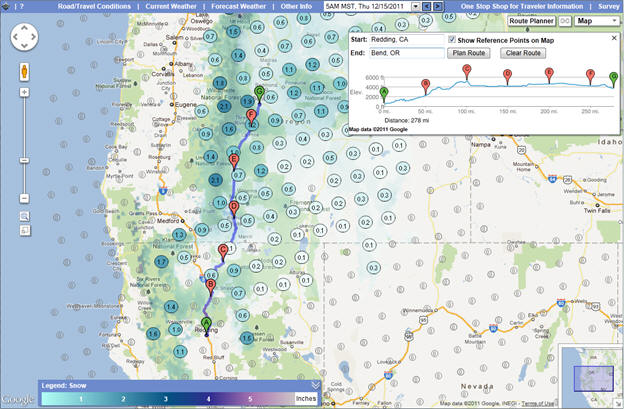
You can drill down to further detail for the forecast, including predicted air temperature, wind speed, precipitation and snow. Here's further detail on the snow forecast for 12/15/2011 – notice that with the exception of Siskiyou Pass, snow isn't forecast for I-5 during this time period. However, other routes to the east such as US 97 will likely see some snow:

This is where the OSS Route Planner comes in handy. After clicking on the Route Planner button in the upper right portion of the map, we selected Redding, CA as the start and Bend, OR as the end, and then pressed the Plan Route button. Notice several things below: the elevation profile of the route is shown with reference points at labeled locations, and the reference points are shown on the map in conjunction with the route. We piggy-back on Google's routing functionality and, at present, only show the primary route returned from Google between the start and endpoint. Of course there is no guarantee of what conditions you will encounter in your travels, particularly in winter months. Take this into account when selecting routes, as you should in conjunction with any decision you might make when planning a trip, use as much information as possible in planning your trip, and always use good judgment so-as to not put yourself and others at risk.
Here's the Route Planner screen we referred to previously:

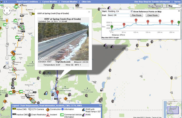
You can zoom in to see further detail and you can switch to other layers while using the Route Planner. Here we take a look at the Road/Travel Conditions layers and see plenty of chain restriction markers. One of the cameras along the route in Oregon shows what appears clear road and sky conditions, but there is some snow along the side of the road. Given the forecast above, that will likely change. And, there may still be snow and ice on the road in shaded spots, so caution is advised.

In this update, we've only scratched the surface of information that is available in OSS. Take a closer look at http://oss.weathershare.org/. And, gather as much information as possible from OSS and all available sources both before and while traveling to help plan for safe trips.

